Mapping the L.A. wildfires from Palisades to Eaton and Hurst
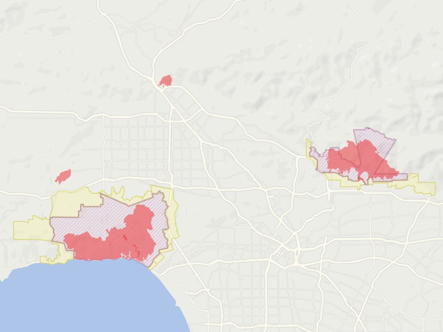
BY BONNIE BERKOWITZ and AARON STECKELBERG, Los Angeles Wildfires Show No Signs of Slowing as Devastation Mounts We’re tracking the fires in Los Angeles, California. See maps of recently burned areas and key locations in the vicinity of the fire. After igniting Tuesday, several wildfires are ripping through Los Angeles County, forcing widespread evacuations and causing power outages as firefighters struggle to combat the blazes. The Palisades Fire, which broke out near the Pacific Palisades neighborhood, has burned over 22,000 acres. The Eaton Fire, which erupted to the northeast, has burned more than 14,000 acres, according to Cal Fire, while the Hurst Fire, burning in the north, has spread to over 700 acres. The Kenneth Fire by Hidden Hills crosses over Los Angeles and Ventura counties and started Thursday night, has grown to over 1,000 acres. A person has been taken into custody on suspicion of arson in connection with the Kenneth Fire, authorities said Thursday. Firefighters have contained three fires: the Lidia Fire, which emerged in Antelope Valley on Wednesday afternoon; the Sunset Fire, which started Wednesday evening in the Hollywood Hills; and the Woodley Fire, which broke out in the Sepulveda Basin of the San Fernando Valley. Here’s what to know about the six active fires in Los Angeles as of 8 a.m. local time. Spread and containment figures are from Cal Fire. Palisades Fire (11 percent contained): The blaze has burned through more than 22,000 acres in and around Pacific Palisades and killed at least five people. Los Angeles Fire Department Chief Kristin Crowley said the fire has destroyed more than 5,300 structures since Tuesday. The fire is now spreading toward Brentwood, where the Getty Center is located. Eaton Fire (15 percent contained): On the city’s east side, near Pasadena, the fire has killed at least six people and burned through 14,117 acres. More than 7,000 structures have been damaged or destroyed by this fire, officials said. Kenneth Fire (80 percent contained): The fire in the Calabasas and Hidden Hills areas was first reported Thursday afternoon and has spread to 1,052 acres. A person was taken into custody Thursday afternoon on suspicion of arson in connection with the fire, but there was not enough evidence to charge them with a crime, Los Angeles Police Department Assistant Chief Dominic Choi said Friday. Lidia Fire (100 percent contained): Firefighters have contained the fire, which began in Antelope Valley on Wednesday afternoon. According to Cal Fire, it burned through 395 acres. Hurst Fire (76 percent contained): In the north, near San Fernando, the fire has covered 799 acres. Archer Fire (zero percent contained): The blaze broke out Friday morning in the Granada Hills area, northwest of downtown Los Angeles, during what officials described as “erratic winds.” It has burned about 19 acres so far. For more detailed maps of how each fire is spreading, check here. Evacuating thousands of residents Immediate evacuation orders have been issued since last Tuesday night, forcing tens of thousands of residents to leave their homes. Areas under evacuation orders as of 3:38 p.m. ET, Sat. Fires detected in a 1/4 mile area as of 3:38 p.m. ET, Sat. Calabasas, Pop. 22,200 Around 50,000 people under evacuation orders. Brentwood Pop. 1,400. Palisades Fire. Malibu, Pop. 29,800. Pacific Palisades, Pop. 20,100. Santa Monica,. Pop. 89,900, 2 MILES Pacific Ocean. ANGELES NATIONAL FOREST. 2 MILES 32,500 people under evacuation orders. La Cañada Flintridge. Pop. 19,500. Altadena, Pop. 45,400. Eaton Fire, Sierra Madre. Pop. 10,700. Pasadena Pop. 133,600 Los Angeles is burning Relatives evacuated. Childhood landmarks burned to the ground. What it’s like to report on the wildfires ripping through Los Angeles. Maxar, a commercial imaging firm, captured the destruction of the Los Angeles fires on Wednesday afternoon. The satellite imagery reveals how entire neighborhood blocks were completely burned. The following shows destroyed houses near Marathon Road in Altadena, California. Using shortwave infrared imagery, Maxar captured shots of burning homes in Altadena. Below is a blended image showing the hundreds of fires that ravaged the area. Satellite image from January 8 ©2025 Maxar Technologies How the Santa Ana winds are making the fires worse Both Palisades and Eaton fires grew exponentially in a matter of hours, due to fierce Santa Ana winds and dry vegetation from a rainfall shortage. On Wednesday morning, Cal Fire reported the Palisades fire at 2,921 acres; by 4 p.m. Eastern, the fire had grown over five times in size to almost 16,000 acres. Santa Ana windstorms happen regularly in southern California, but experts say the current winds fueling the fires are stronger than usual, with gusts 65 to 75 mph expected Wednesday afternoon, according to
 BY BONNIE BERKOWITZ and AARON STECKELBERG,
Los Angeles Wildfires Show No Signs of Slowing as Devastation Mounts We’re tracking the fires in Los Angeles, California. See maps of recently burned areas and key locations in the vicinity of the fire.
The Kenneth Fire by Hidden Hills crosses over Los Angeles and Ventura counties and started Thursday night, has grown to over 1,000 acres. A person has been taken into custody on suspicion of arson in connection with the Kenneth Fire, authorities said Thursday.
Firefighters have contained three fires: the Lidia Fire, which emerged in Antelope Valley on Wednesday afternoon; the Sunset Fire, which started Wednesday evening in the Hollywood Hills; and the Woodley Fire, which broke out in the Sepulveda Basin of the San Fernando Valley.
Here’s what to know about the six active fires in Los Angeles as of 8 a.m. local time. Spread and containment figures are from Cal Fire.
- Palisades Fire (11 percent contained): The blaze has burned through more than 22,000 acres in and around Pacific Palisades and killed at least five people. Los Angeles Fire Department Chief Kristin Crowley said the fire has destroyed more than 5,300 structures since Tuesday. The fire is now spreading toward Brentwood, where the Getty Center is located.
- Eaton Fire (15 percent contained): On the city’s east side, near Pasadena, the fire has killed at least six people and burned through 14,117 acres. More than 7,000 structures have been damaged or destroyed by this fire, officials said.
- Kenneth Fire (80 percent contained): The fire in the Calabasas and Hidden Hills areas was first reported Thursday afternoon and has spread to 1,052 acres. A person was taken into custody Thursday afternoon on suspicion of arson in connection with the fire, but there was not enough evidence to charge them with a crime, Los Angeles Police Department Assistant Chief Dominic Choi said Friday.
- Lidia Fire (100 percent contained): Firefighters have contained the fire, which began in Antelope Valley on Wednesday afternoon. According to Cal Fire, it burned through 395 acres.
- Hurst Fire (76 percent contained): In the north, near San Fernando, the fire has covered 799 acres.
- Archer Fire (zero percent contained): The blaze broke out Friday morning in the Granada Hills area, northwest of downtown Los Angeles, during what officials described as “erratic winds.” It has burned about 19 acres so far.
For more detailed maps of how each fire is spreading, check here.
Evacuating thousands of residents
Immediate evacuation orders have been issued since last Tuesday night, forcing tens of thousands of residents to leave their homes.
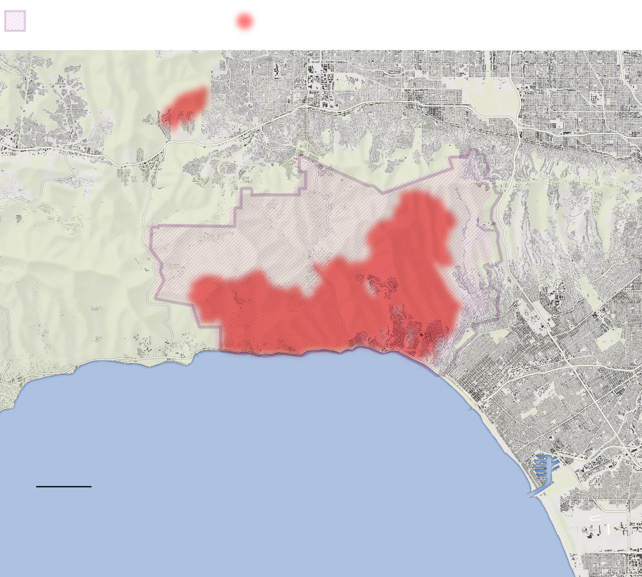
Areas under evacuation orders as of 3:38 p.m. ET, Sat. Fires detected in a 1/4 mile area as of 3:38 p.m. ET, Sat. Calabasas, Pop. 22,200 Around 50,000 people under evacuation orders. Brentwood Pop. 1,400. Palisades Fire. Malibu, Pop. 29,800. Pacific Palisades, Pop. 20,100. Santa Monica,. Pop. 89,900, 2 MILES Pacific Ocean.
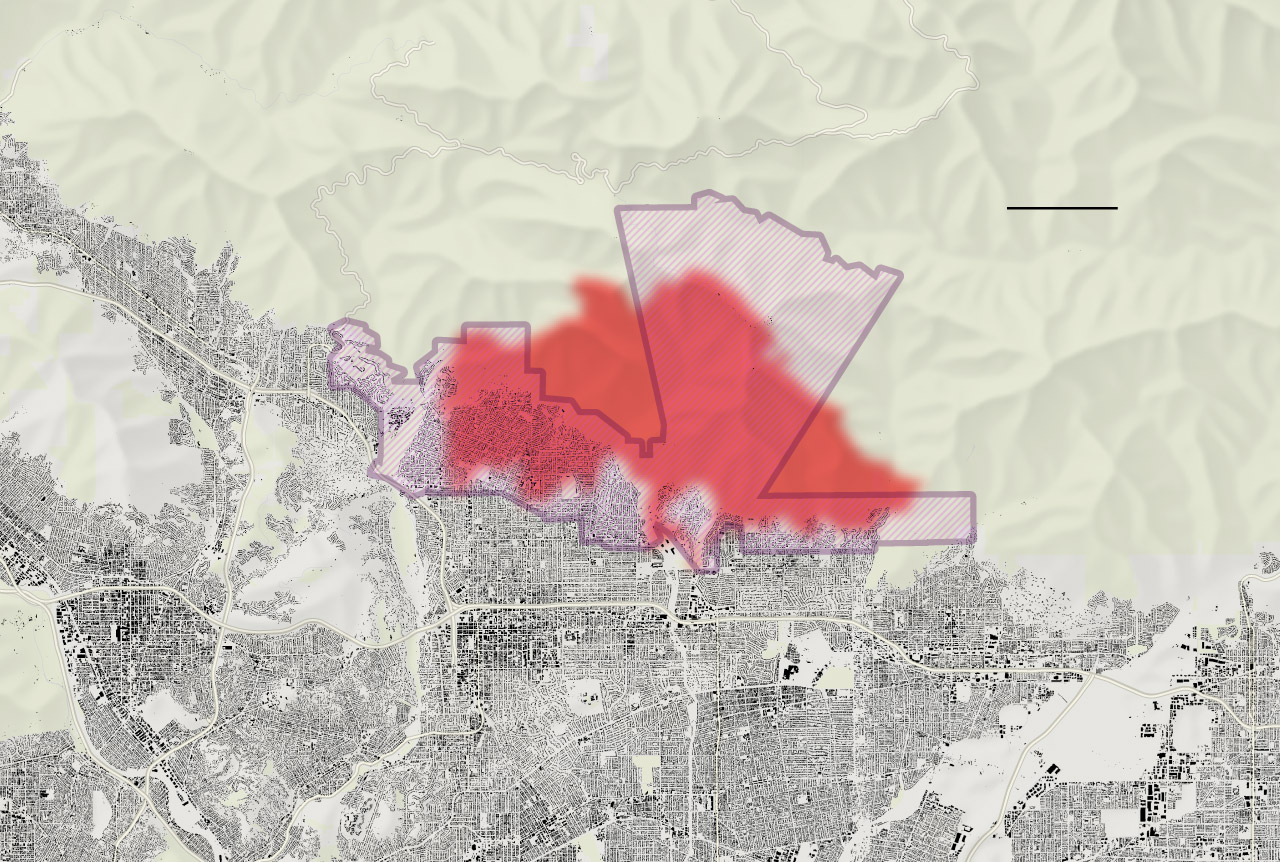
ANGELES NATIONAL FOREST. 2 MILES 32,500 people under evacuation orders. La Cañada Flintridge. Pop. 19,500. Altadena, Pop. 45,400. Eaton Fire, Sierra Madre. Pop. 10,700. Pasadena Pop. 133,600
Maxar, a commercial imaging firm, captured the destruction of the Los Angeles fires on Wednesday afternoon. The satellite imagery reveals how entire neighborhood blocks were completely burned. The following shows destroyed houses near Marathon Road in Altadena, California.
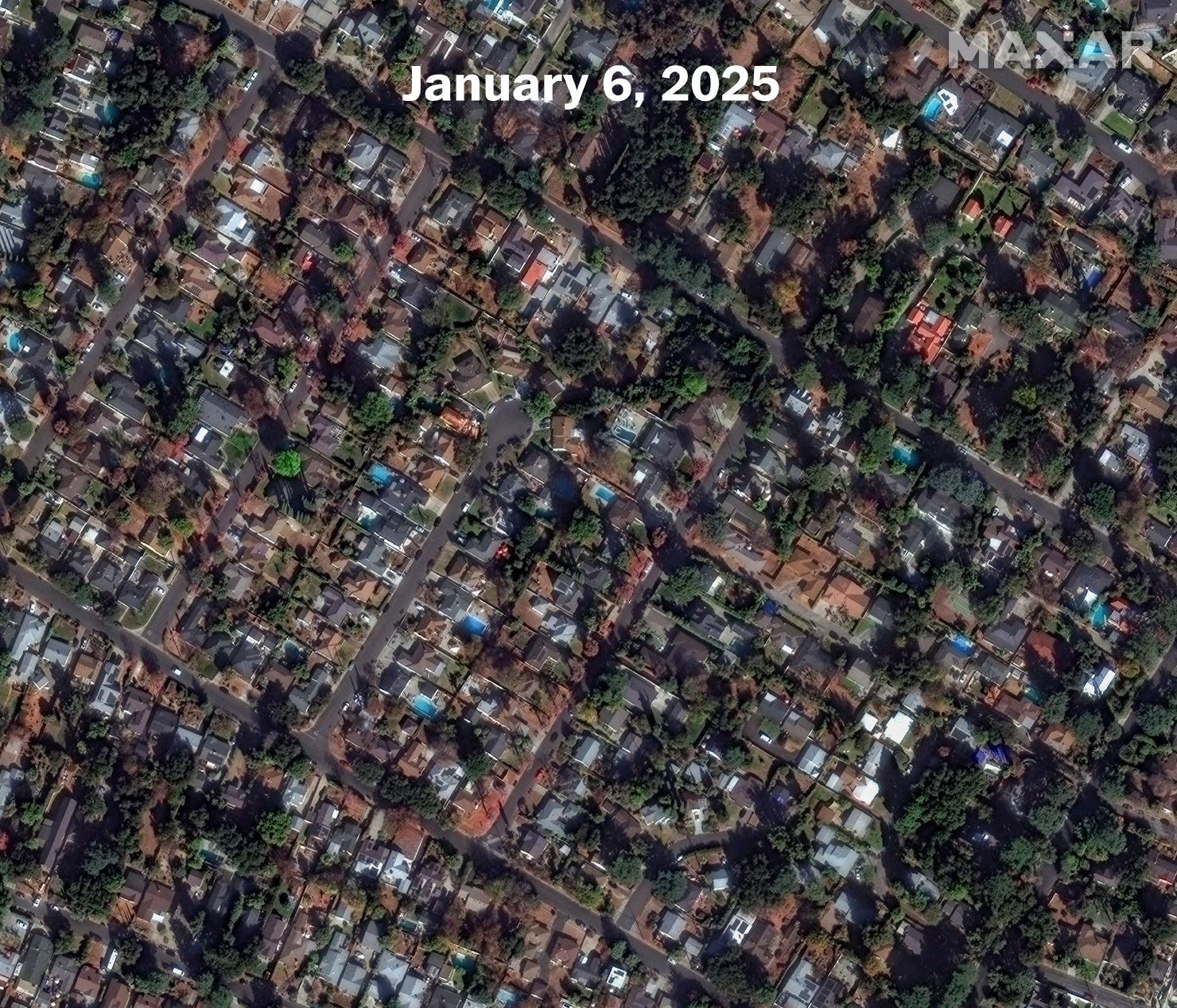
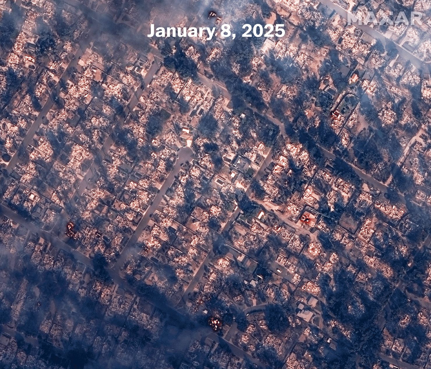
Using shortwave infrared imagery, Maxar captured shots of burning homes in Altadena. Below is a blended image showing the hundreds of fires that ravaged the area.
How the Santa Ana winds are making the fires worse
Both Palisades and Eaton fires grew exponentially in a matter of hours, due to fierce Santa Ana winds and dry vegetation from a rainfall shortage. On Wednesday morning, Cal Fire reported the Palisades fire at 2,921 acres; by 4 p.m. Eastern, the fire had grown over five times in size to almost 16,000 acres.
Santa Ana windstorms happen regularly in southern California, but experts say the current winds fueling the fires are stronger than usual, with gusts 65 to 75 mph expected Wednesday afternoon, according to NOAA. The windstorm is expected to continue over the next few days, with the strongest gusts forecasted Thursday afternoon into Friday morning.
Pressure changes create winds
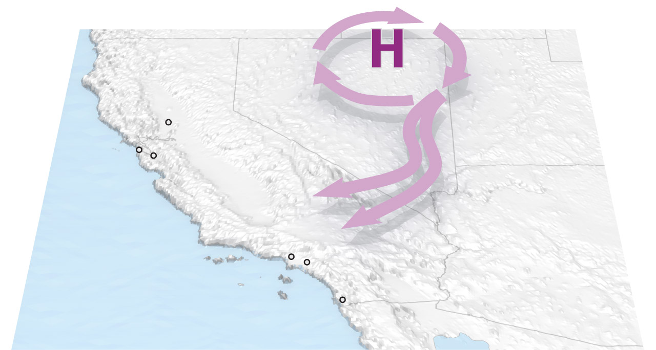
Santa Ana winds occur when a high-pressure system forms over the deserts of the Great Basin. The high pressure circulates clockwise, pushing air westward toward the lower-pressure areas of the coast. This region experiences Santa Ana windstorms multiple times a year.
CALIFORNIA GREAT BASIN.
Sacramento
NEVADA
San Francisco
San Jose
Los Angeles
Santa Ana
San Diego
Air gets hotter and drier
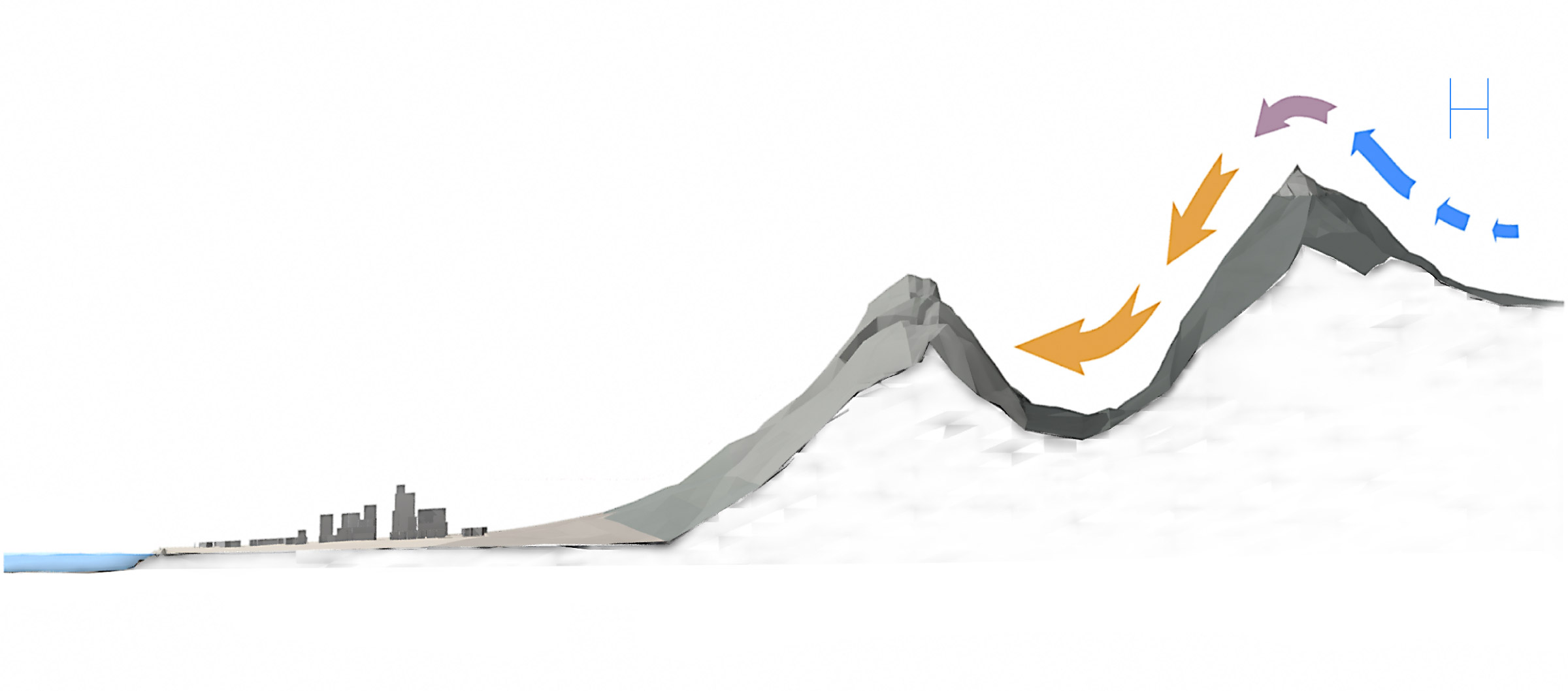
Santa Ana winds usually occur from fall to spring or even early winter, when a high-pressure system forms over the deserts of the Great Basin. The high pressure circulates clockwise, pushing air westward toward the lower-pressure areas of the coast.
Cold air Mountains, Warm dry air Valley, Coast.
Gaps in the mountains form wind tunnels
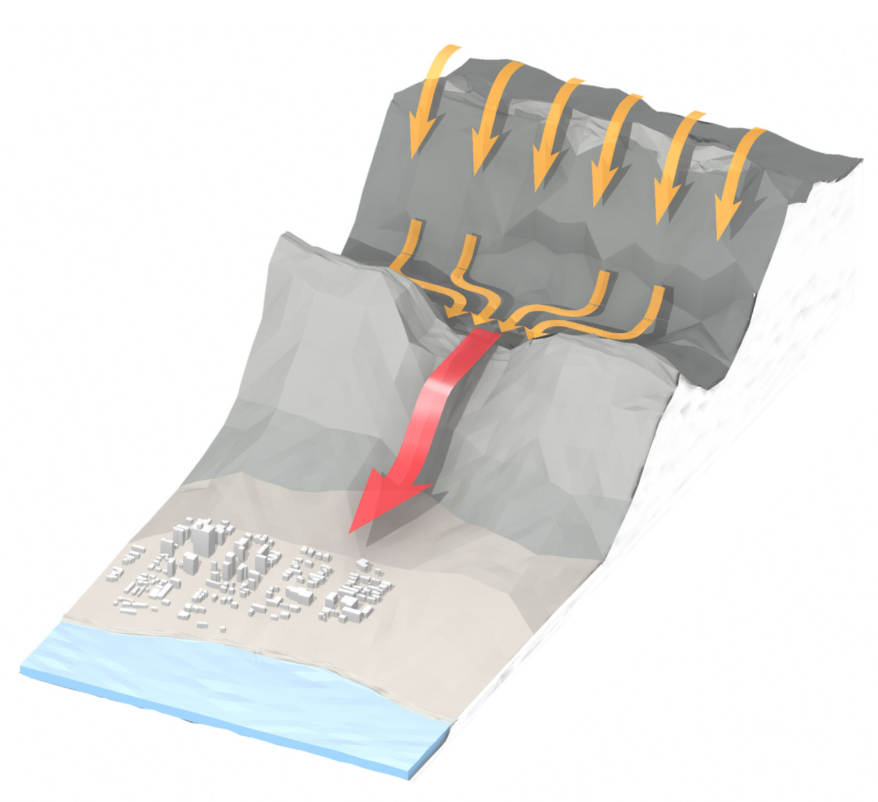
The wind speeds up as it pours over the mountains, particularly where it is forced through passes and canyons like water through a funnel. Gusts of 40 to 60 mph or even stronger are common. Suddenly dry, warm — or downright hot — air is whooshing toward the coast.
Warm, dry air Mountains, Fast-moving, hot, dry air Valley, Coast.
The result is like a giant hair dryer
The wind careens over low-lying Southern California, parching vegetation in its path that can easily become fuel for a fire. Extremely wet conditions in fall 2023 to spring 2024 resulted in the growth of large areas of vegetation, which have created fuel for these wildfires now plaguing the Los Angeles area.

 newsroom


